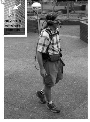
Drishti is a wireless pedestrian navigation system. It integrates several technologies including:
- Wearable computers
- Voice recognition and synthesis,
- Wireless networks
- Geographic Information System (GIS)
- Global positioning system (GPS)
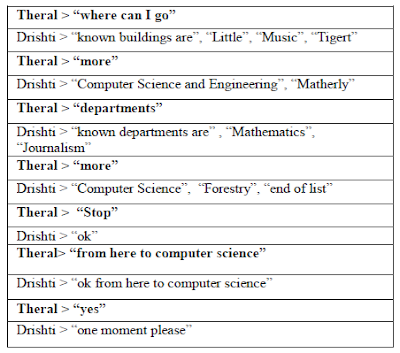
Drishti augments contextual information to the visually impaired and computes optimized routes based on:
- user preference
- temporal constraints (e.g. traffic congestion)
- dynamic obstacles (e.g. ongoing ground work, road blockade for special events)
The system constantly guides the blind user to navigate based on static and dynamic data. Environmental conditions and landmark information queried from a spatial database along their
route are provided on the fly through detailed explanatory voice cues. The system also provides capability for the user to add intelligence, as perceived by the blind user, to the central server hosting the spatial database.
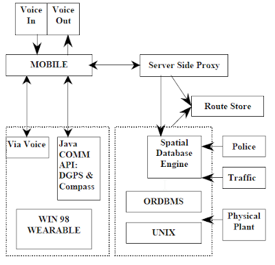
Hardware:
- Wearable computer
- Differential GPS (DGPS) receivers
- Wireless network
Software Components:
- Spatial database: ESRI’s ArcSDE, is a spatial database engine, which acts as a gateway to manage GIS datasets on a Relational Database Management Systems
- Route Store
- Mapserver
- IBM’s ViaVoice: The runtime and IBM’s implementation of the Java Speech API are being used to provide a spoken dialogue user interface
The system itself is built for navigation around a campus as well as the streets but the main idea is similar to what we are looking for. It also integrates a number of technologies together... :)
What do you think?
The actual paper can be found here.
Maria.
i like =) mine and ryans system also uses a wearable computer + battery, so we can link them up through that
ReplyDelete